Difference: FRCVTSGDemos ( vs. 1)
Revision 12012-05-18 - DamianLyons
| Line: 1 to 1 | |||||||||
|---|---|---|---|---|---|---|---|---|---|
| Added: | |||||||||
| > > |
BackgroundA representation that combines depth and image information is Birchfield and Rangarajan (2007)'s spatial histogram or spatiogram. The image spatiogram extends an image histogram with a Gaussian distribution per histogram bin that summarizes the image location for the image pixels that fall in that histogram bin. However, image spatial information is related in a rather complication fashion to the scene spatial information. We proposed an extension to the spatiogram, called the Terrain Spatiogram, TSG, in Lyons (2009) in which the image spatial information is replaced by terrain spatial information. The image below shows a picture of chair on the right. In the middle is a stereo disparity map of the same chair. In the right is a terrain spatiogram of the chair. You can see that it is a 3D object. The origin of the spatiogram is centered with respect to the 3D cloud of data points that make up the chair and the scale is the same. It looks like a 'blurred' version of the chair.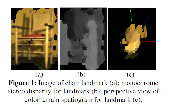 The advantage of the TSG is that it takes up much less space than either the image or the 3D point cloud but can be used effectively to recognize the landmark.
--+++Pictures
Coming soon, lots of images of spatiograms for different natural and artificial landmarks and also for textures.
Meanwhile, for more information, see the papers at ICRA 2010 and IROS 2010.
The advantage of the TSG is that it takes up much less space than either the image or the 3D point cloud but can be used effectively to recognize the landmark.
--+++Pictures
Coming soon, lots of images of spatiograms for different natural and artificial landmarks and also for textures.
Meanwhile, for more information, see the papers at ICRA 2010 and IROS 2010.
| ||||||||
Ideas, requests, problems regarding TWiki? Send feedback